Showing posts with label Plan of Nashville. Show all posts

Wednesday, January 22, 2014

Someone needs to kick this ballpark concept until it bleeds baseball

Practically no culture critics that I am aware of have weighed in on the Mayor's new Sulphur Dell ballpark design. That was not the case in 2006, when the Sounds and developers had a design for the Riverfront. I recall weeks of discussion about the design.

Christine Kreyling, co-author of The Plan of Nashville, wrote of the Sounds proposal at the time that it did not integrate the ballpark facility successfully with the other mixed-use development that was part of the project. Looking over the images released for Sulphur Dell, I wonder if Kreyling's opinion would be that different of Mayor Karl Dean's project for North Nashville. Rather than creating a cozy fit between ballpark, residential and parking garage, Sulphur Dell could be accused of repeating the "willy-nilly wedged blocks" of 2006 "Soundsville". Designers seemed to have fit the garage and the residential buildings more carefully along the greenway beyond the outfield wall, but the ballpark seems dropped down with little thought to continuity.

The ballpark in the Sulphur Dell plan itself looks like a low-profile afterthought, almost like the mission here is to express that this is strictly a real estate deal and not the resurrection of hollowed ground of primordial baseball diamonds of old (as went the marketing campaign went before the proposal was approved). In 2006, Kreyling reported that developers intended that residential and ballpark not strive for integration "in case at some point in the future the stadium is demolished." Is the same logic in effect at Sulphur Dell in 2014? Because the new ballpark seems to be strictly an expendable utility player on this field of dreams.

Kreyling also criticized the awkward way that the rounded shell of the 2006 grandstands "stuck on" a squared porch "diluted the strength of the building form." The Sulphur Dell proposal differs in that the rounded wall behind home plate is centered between blocks of its own squared porch instead of pulled toward a corner, but the style looks similar: the Dell's squared off porch seems to nullify the classic ballpark form.

Rather than emerging unmistakably streetside as a ballpark, the form seems to be swallowed into a blank stone wall. If you took the literal reference of the name of the place off the Jackson St. windows, would the building itself communicate "ballpark" or "baseball"? Or could the rounded shell that peeks out from its sandwich between blocks merely seem to be any building suiting any purpose at all? Indeed, the Jackson St. exterior looks like a hoary back wall to the development footprint to the degree that they could add to it a loading dock that would not appear to be out-of-place.


After the blight of Greer Stadium, Nashville may feel lucky to have any new ballpark design at all. But the one they are planning at Sulphur Dell seems to recede to the point of insignificance relative to the real estate around it. One reviewer of stadiums across the USA referred to the exterior of Titans' LP Field as "unspectacular", and I am struck by how the stone and glass skin of the new baseball park resemble points along the blasé hull of LP Field. If baseball in North Nashville history is as venerable, is as important as boosters of the Mayor's plan have insisted for weeks now, don't we deserve a more robust and unmistakable baseball aesthetic for the old ball game, befitting the history of Sulphur Dell?


UPDATE: one of the reasons that the ballpark part of the Sulphur Dell development is more utility than frontline may be because the Sounds club owner, Frank Ward, is more of a real estate mogul than a baseball guy. In a November interview, Mayor Karl Dean emphasized the Ward family's real estate credentials to insist that the real estate would succeed:

I think people need to remember that the current owners of the Sounds came into baseball with a background in real estate development. In fact, the son of Frank Ward, who's the principal owner of the Sounds, that's how he makes his living is real estate development and building student housing. So they have a lot of experience and we're very confident that they want this to move forward.

I don't have a problem with this family wanting to make some money on their real estate business, but the reality that the ballpark element in the development is downplayed and the appointments in the ballpark are meager suggests that baseball is not the focus that it should be.

When I look at Memphis's Autozone Park in contrast I think, "This looks like a park baseball people would build":



Sunday, December 17, 2006

Plan Of Nashville's Idea for Morgan Park


Here is Christine Kreyling's and the Nashville Civic Design Center's vision for the re-development of the Morgan Park area. In the Plan of Nashville, Kreyling proposes expanding Morgan Park west to the Werthan property and east to the river. The currently operational Werthan Packing Plant (corner of Hume and 5th) would be closed and torn down and a Governor's mansion, suited for functions but not for residence, would anchor that corner.

The recreational facilities in the park would give way to a "Governor's Green" with a reclaimed surface water shed to the river (it is currently buried). In one drawing, the baseball diamond has been moved east between 2nd and 3rd. However, our community center would go away in Kreyling's plans. This re-development would be part of what Kreyling calls the "River District," which includes Germantown, East Germantown, Hope Gardens, parts of Cheatham Place (a.k.a., Historic Buena Vista) and the blocks of Salemtown south of Garfield.

This is an ambitious plan that I don't see happening any time soon, and with the money that Parks is about to invest in a new playground, community center renovations, and diamond upgrades, I don't see this plan happening in my lifetime. I also have a hard time understanding how one could justify doing away with a neighborhood community center, even in the name of creating more green space and ridding ourselves of unsightly Werthan Packing.

Tuesday, October 10, 2006

Living the Plan: Won't See or Be Seen

Today is October 10--which is the deadline for RSVP'ing for the Living the Plan of Nashville session on October 18--and I am tossing my invitation. It looks like an important lunch and seminar for Nashille's design future, but costs (lunch, $70; seminar, $200) are budget-busting for us. Somebody who can afford to go will have to fill me in on the details.

Thursday, August 24, 2006

First Look at Riverfront Redevelopment Concepts

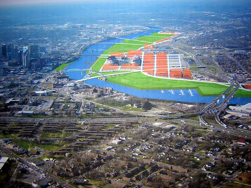
Tonight's Riverfront Redevelopment Forum was well-attended and very informative. I'll post more details in the morning. For now, I am posting the two large-scale concept rendering options that the design came up with based on many factors, including last year's public feedback. Since they are large-scale, they do not account for redevelopment in the North End to the degree that they do on the East Bank. We were told that the North End would be more in focus at one of the future forums on small-scale redevelopment.


The first option assumes that the interstates as they currently stand will disappear or get scaled down to what The Plan of Nashville calls "urban boulevards." A good portion of the East Bank around LP Field would be devoted to green space (in green) and residential/mixed-use (in orange) with a street grid. A marina is suggested for the southern bend.


The second option assumes that the interstates stay. To create more room for marinas and landings where people can go to the water, a channel would be cut around the east side of LP Field. That would essentially create a 275-acre island in the river for green space and residential/mixed use. Future expansion also depicted would include digging more channels to create smaller islands that would not be accessible by car, but remain bird habitats and fishing spots (the channels would be stocked).

Keep in mind that these conceptual drawings depict both short-term and long-term (20 years) redevelopment. I have to say that I was pretty impressed with these plans. I think the second option is particularly intriguing.

Tuesday, January 03, 2006

Cumberland Corridor

About a month ago I mentioned in passing that I had attended one of the Riverfront Development public meetings held here in the North End. I did not take the time to say much more about it because it did not strike me as significant enough that it could not wait. Now that holiday hubbub is past us, I'll give it the reflection it is due.

I did not see anyone from Salemtown in attendance, and there were a handful of Germantown people there that I could identify. Most of the rest seemed to be consultants, developers, business leaders, and urban designers from various places. Therefore, the tenor of the meeting seemed very different than if those in attendance would have been more focused on how neighborhood issues might affect or direct plans to "connect" Nashville (à la "The Plan of Nashville").

I sat in one of the small groups clustered around a table looking at a map oriented to the river almost exactly like the picture above, but without the detail (the map above is actually an imagined blueprint of the Riverfront). We discussed the things we would like to see along the Riverfront in the area from Shelby Bottoms on the south to the Cumberland River Greenway at I-65 on the north. And we made notes directly on the map. At the end of the discussion time, each small group presented its ideas to the others and then everyone voted for their three favored ideas for developments.

As I said before, if the discussion had involved more neighborhood people it might have been very different. I raised some eyebrows when I spoke of neighborhood boundaries and identity. Others had grander designs. But the conclusions reached would have also been different, in my opinion, if the orientation of the map had been different. The center of the map seemed to be the East Bank/Coliseum area with the Cumberland curving toward the left-side of the map, leaving a relatively smaller swath of North Nashville, Downtown, and South Nashville in view.

I believe that the map's orientation had a good deal to do with the group spending most of its time talking about developing neighborhoods on the East Bank and connecting them with others on the East End. The only time our group focused on North End development was to talk about the old Neuhoff Complex, the Central Wastewater Treatment Facility, and "Nashville Island" (which used to be "Burns Island"). By my unscientific tally, there were perhaps 10 East Nashville development ideas for each North Nashville idea. Even the discussion of the possible new ballpark had to do with whether to build it on the old Thermal Site on the West Bank now or to build it on the East Bank south of the Coliseum later as a spur for East Bank neighborhood growth. I concluded that the total lack of discussion about the South End beyond SoBro and Rolling Mill Hill also resulted from the eastward orientation of the map.

I do not know if the Nashville Civic Design Center oriented the map because they intentionally wanted to focus the discussion the East Bank, but our chat did focus in that direction, and I could not gather that there were more East Enders present than anyone else. The whole NCDC emphasis on connecting Nashville neighborhoods into one city seemed undercut by the NCDC map itself.

Friday, March 11, 2005

"The Plan of Nashville": Whose Plan? Which Nashville? Part IV

In this final response to The Plan of Nashville’s calls to replace I-65 with an urban boulevard, I want to examine MetroCenter’s holdings in North Salemtown. In particular, I want to consider whether there is any indication in the actual geography that MetroCenter is interested in neighborhood-friendly development. If there were such indicators, it would make the idea of doing away with the I-65 barrier more palatable.

As I wrote in Part III of this series, MetroCenter owns the only vacant residential properties in the upper “commercial zone” of North Salemtown. However, the side-by-side properties along MetroCenter Blvd. look more like the gateway to MetroCenter’s commercial developments farther north than a nascent residential block.


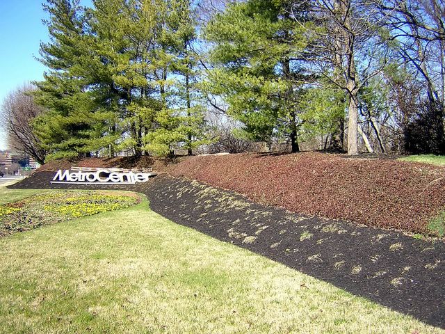
MetroCenter property on MetroCenter Blvd., north of Clay Street. Photograph by S-townMike. Posted by Hello
Half of the thin strip of land is landscaped with a steep, narrow grade and trees lining the crest: easy on the eyes of passing motorists on MetroCenter Blvd., but hard on houses if people were actually to live here. Moreover, if this were a gateway to an embryonic North Salemtown community rather than a commercial district, then quite logically, the industrial park-like “MetroCenter” sign would not be facing south at the tip of the northwest corner of Salemtown. The steep grade and the sign collectively encourage people to by-pass Salemtown altogether and to motor to the commercial offerings.

What, then, of MetroCenter’s holdings of vacant residential land in the lower “residential zone” of North Salemtown? I previously asserted that if zoning stays as is and MetroCenter holds a few vacant residential parcels in a predominantly residential block, then I have no worries about The Plan of Nashville’s call to do away with I-65.


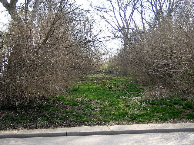
MetroCenter property on 3rd Ave., south of Clay Street. Photograph by S-townMike. Posted by Hello
However, the properties as they currently stand south of Clay seem to be lying fallow, overgrown, and unkempt. If we gauge MetroCenter’s commitment to the well-being of the Salemtown neighborhood based on the quality of development of their residential properties, we come up empty. The MetroCenter Blvd. gateway to their commercial holdings with its dark-wood mulched flowerbeds, strategically placed pine trees, and gleaming metallic sign seems to be dramatically more developed and inviting, despite its total lack of viable space for people to actually live.

Sunday, March 06, 2005

"The Plan of Nashville": Whose Plan? Which Nashville? Part III

“Carefree Highway” was one of Gordon Lightfoot’s hits in the 1970s. I must have been in junior high when it got the most airtime, but I remember misunderstanding his lyrics and changing the word "Carefree" to “Every.” On those rare occasions when I hear it now, I still catch myself wrongly intoning, “Every Highway," which implies something other than what the song means.

In the song a highway is carefree because it provides the freedom to slip away from cares and the routines that tie us down, even if those things include the “good old faithful feelin’ we once knew.” Highways represented ironic flight for Gordon Lightfoot’s wayward generation.

They seem to represent something very different now. For those who authored of “The Plan of Nashville,” highways rip the fabric of neighborhoods. I do not disagree, but I do claim exceptions for some neighborhoods. From my point of view highways both slice up neighborhoods and provide barriers to keep other economic and political forces at bay.

I have already made the latter argument about the inner loop of I-65 at Salemtown between 3rd Avenue and MetroCenter Blvd. To be specific, I-65 is a wall that acts as a disincentive for the out-of-state company, MetroCenter, to expand farther south than it already has. In Part II, I mustered some numbers to show that MetroCenter owns a substantial amount of property in North Salemtown with no clear or evident inclination to support a neighborhood.

However, I want to be fair to MetroCenter, too. There are other dynamics in North Salemtown that could lead to residential development and business expansion compatible with neighborhood interests. If those other dynamics hold the day, then turning I-65 into an urban boulevard is not a bad idea. Those dynamics are contained in zoning details.

First, I will breakdown the numbers. The slice of North Salemtown severed by I-65, is itself bisected east to west by Clay Street, which runs from 3rd Avenue to 6th Avenue. There are no Salemtown residences to the north of Clay. The overwhelming majority of parcels are zoned “vacant commercial.”

Here is a rundown of the 30 parcels contained between Clay and Dominican:
  • MetroCenter owns 19
  • CB&J Properties, LLC owns 5
  • Strickland Enterprises owns 3 (none other than the same company that makes Strickland's Surpeme Salads. I already took them to the weblog woodshed for making 5th Ave. and Jefferson Street look trashy).
  • SouthCentral Bell owns 2
  • One parcel is owned by an individual and his wife, but there is no residential structure on the property.
My first expression of fairness toward MetroCenter: of the 30 Salemtown parcels between Dominican and Clay, there are 3 zoned “vacant residential,” and they are all owned by MetroCenter. There might be a blessing-in-the-disguise-of-MetroCenter here, given their residential zone holdings. However, let’s hold that "'god-bless-you' in abeyance” (nod to Seinfeld) for consideration at a later date and a later entry.

For now, I want to cross Clay Street to the south and focus there. All of the North Salemtown residential units sit in the block south of Clay, north of I-65, west of 3rd, east of 6th. That block is relatively small, measuring 120’x950’x150’x 1020’. MetroCenter owns 7 parcels there distributed across the block. Currently all of MetroCenter’s properties in the “residential block” are zoned “vacant residential” (in Zone terms, "R6," meaning single-family dwellings).
Time for the second expression of fairness to MetroCenter: if the zoning stays as is on each of those properties, then perhaps The Plan’s vision of controlled, mixed residential and commercial properties on MetroCenter parcels might come come true for North Salemtown. And if MetroCenter is community-minded to North Salemtown, then perhaps they might be community-minded toward the rest of Salemtown if the wall of I-65 ever came down as The Plan envisions.

However, I am not quite ready to extend benefit of the doubt to MetroCenter. A problem remains. It is the unknown factor in the equation: we will not know what MetroCenter’s intentions for these parcels are until they tell us. For all we know they may well intend to push legally to change the zoning.

If the planning commission and Metro Council stand firm on keeping residential zoning, then MetroCenter has 7 small and randomly placed properties “on the residential block” on which to build single family homes. In that light the Plan to take out the interstate might work along side a strongly organized Salemtown as a counterbalance just in case MetroCenter decides to start acting like a wise guy.

For the meantime we can look to I-65 as a figurative means of evading MetroCenter’s drive to acquire, while repeating Gordon Lightfoot’s refain, “Carefree Highway, let me slip away, slip away on you.”

Friday, March 04, 2005

"The Plan of Nashville": Whose Plan? Which Nashville? Part II


Zoned sketch of North Salemtown. Source: www.nashville.gov.
I would like to take a second look at the proposal, in “The Plan of Nashville,” to turn the I-65 corridor into an urban boulevard in order to redevelop the interstate’s footprint and “reintegrate” the neighborhoods to the city. As I mentioned in a previous entry, I-65 cuts a small slice of North Salemtown off from the rest of Salemtown. I expressed reservations about The Plan’s proposal with MetroCenter holding so much of the land in that small area.

Well, I went to the Metro Planning Department’s virtual map room on a fact-finding mission. By the way, the Planning Department’s website is great for tracking information about parcels of land, especially if you need help locating codes violators. It also allows you to filter the map with “layers” to give you any kind of information about neighborhoods. I recommend it.

The facts seem to sustain my concerns about MetroCenter, which is not a Tennessee-based company:
  • MetroCenter owns 26 of 53 parcels in the North Salemtown area cut off by I-65.
  • Most of MetroCenter’s holdings are in commercial zones.
  • MetroCenter owns the largest parcels in the area.
In sum, MetroCenter has increased its landholdings south of Dominican Drive, possessing nearly half of all parcels and probably most of the acreage of North Salemtown. Most of its holdings are zoned as "vacant commercial," and all of its holdings are vacant period.

One does not have to stretch very far from these facts to deduce, as I have, that MetroCenter will more than likely develop most of North Salemtown commercially with or without respect for urban design or for the character of neighborhoods. At the very least we can conclude that MetroCenter's land holdings give them the power and influence to make them the force with which to be reckoned if planners and designers advance visions for redevelopment of the I-65 corridor. Near northside neighborhood organizers defending the community's interest will have to find some counterbalance to MetroCenter's influence should I-65 go away.

In the next part of my commentary about The Plan’s plan for I-65, I’ll breakdown the numbers on the property holdings in North Salemtown. There is actually a slim hope that MetroCenter might not turn out to be the King Kong I worry about and might actually develop residential properties as The Plan wishes. But based on the power MetroCenter already has through its holdings in North Salemtown, things might not fall that way.

If MetroCenter turns out to be a beast gobbling up parcels of land at the rate it has in North Salemtown, I-65 may be the only barrier keeping it from gobbling up even more tracts further to the south in Salemtown proper.

Stay tuned.

Wednesday, February 23, 2005

"The Plan of Nashville": Whose Plan? Which Nashville?

Looking northwest across I-65 from Salemtown to Salemtown. Is the interstate
a neighborhood scar or a community wall? It depends on whose three-hundred-pound
gorilla is being gored. Photograph and mixed metaphor by S-TownMike. Posted by Hello

The northern loop of I-65/I-40 moving westward sure did a job of carving up north-by-northwest urban neighborhoods. I-40 sliced the old music district around west Jefferson Street nearly in half. I-65 seemingly lopped off a small corner of the old Salemtown neighborhood just east of Mount Vernon Gardens. The question of how to repair the neighborhoods is an important one.

In response, the Civic Design Center introduced “The Plan of Nashville,” which recommends--with much ado and media parade--converting the inner highway loop to an “urban boulevard,” essentially undoing the interstate system around the immediate Nashville neighborhoods. The Plan proposes recreating the loop as a “high street” surrounded by “medium-scale development” with the idea of re-integrating them back into the “urban fabric.”

This seems a great idea from the birds-eye view of Nashville and perhaps from the perspective of west Jefferson Street residents and merchants. But from where I live in Salemtown it does not necessarily put my concerns to bed.

The Metropolitan Planning Department’s plans put the north loop of I-65 as Salemtown’s northern border. While that may leave the four or five blocks between Dominican Dr., MetroCenter Blvd., and I-65 orphaned and nameless, it also essentially gives Salemtown a firm, unequivocal north boundary. The north urban neighborhoods do not tend to sprawl like those in the east and west ends because of such definitive boundaries.

While The Plan of Nashville provides the positives of converting I-65, it does not consider the possible problems. One possible problem is that northern Salemtown will diffuse and the northern neighborhoods will lose some of their unique and bounded character.

A second, more critical downside for Salemtown proper presents itself in the form of the three-hundred-pound gorilla that hulks to the north of I-65. That gorilla is MetroCenter, which is not locally owned. A property investor based in Dallas, Texas owns that vast commercial development.

That Dallas investor has purchased many of the available lots in that small sliver of land north of the interstate already. MetroCenter may be eating up residential property--as it becomes available--to develop it exclusively for commercial purposes. I-65 may currently stand as a barrier to MetroCenter expansion. If so, it also stands as a proverbial “city wall” for Salemtown and the other northern neighborhoods against further corporate acquisition of residential properties.

But what if the interstate is converted to an urban boulevard? What if the large footprint of land on which I-65 sits gets developed? What’s to stop the Dallas-based investors from moving farther south, buying properties, and keeping them unkempt to drive down property values of the residents who choose to continue to live in north Nashville neighborhoods?

MetroCenter does not show any interest whatsoever in encouraging residential components, as The Plan suggests they should, else they would be doing so on the historic part of Salemtown that lies north of I-65. If I were a betting man, I would wager that these outside investors have a lot of clout and enough legal savvy to exempt themselves from sanguine visions of planners and architects.

And that’s what this issue comes down to for me. "The Plan of Nashville” ignores the power formulas that are implicit in design equations. As it is, the only thing standing between Salemtown and the three-hundred-pound gorilla to the north is the interstate. Right now our neighborhood seems to need that wall to keep the ostensible beast of MetroCenter at bay.